On the day before our first Sense of Place Workshop Series Saturday outing, to Etowah Indian Mounds State Historic Site and to McIntosh Reserve Park (Carroll County), I noticed with alarm that my little blue square on my computer, to one with the temperature on it, was red and flashing. There was a National Weather Service winter weather advisory for sleet and possibly even snow that evening. Would we be able to take our first trip after all? A much-beloved elder community member had passed away, too, and I received an email from one of the participants, explaining that he had to attend the funeral and would not be able to join us. I awoke the next morning (Saturday, January 26th) to gray skies and a slightly damp but definitely not snowy lawn. The photographer in our group called to cancel, but my wife kindly agreed to join our trip and take the pictures you see here.
My wife and I arrived at Rico Community Center ten minutes late, at 8:40 am. Only two cars were idling there. Two participants from Serenbe, Margaret and Martha, were there in their gray Prius to match my blue one; and Heather, parent of two Montessori elementary students, was also there. She rode with us, and the Prius caravan was on its way. Though small in number, our group made up for it in enthusiasm about the day ahead.
Reaching Etowah an hour and a half later, we were greeted cordially by Ken Akins, site manager, who informed us that he was at our disposal. I told him about the talk Dr. Crass had given us, and he suggested sharing with us a slide show on the most recent site archaeology -- images using magnetometers and ground-penetrating radar to read the traces of walls and structures that had once stood at Etowah. Many of the images, with traces interpreted by Dr. Adam King, chief archaologist on the project, are
available online here. Below is a photograph of Ken sharing some images with us from his laptop.

One of the recent additions to the visitor center at Etowah is a model of what the village looked like at its peak, between 900 and 1550 AD:

After watching a video about the Southeastern Indians, viewing the museum exhibits, and watching a slide show on the recent archaeological work, it was time to brave the numbing January cold to explore the mounds themselves. Ken happily agreed to lead us on our walk among the mounds. We crossed the moat, now dry, that once encircled the village, probably for both defense and drainage, then traversed an extensive flat area to a slight rise that marked the edge of the original village plaza. For there, it was only a few steps to the many steps leading to the top of Mound A, the Great Temple Mound: at sixty feet high, it is the second largest prehistoric earthen mound in the country, after Monks' Mound at Cahokia in Illinois. Here are two of our group atop Mound A, looking down on Mound C, a burial mound that was excavated many years ago, and subsequently reconstructed:

Below is our group, with Ken leading us, at the base of Mound B. While the chief had a residence atop Mound A, Mound B was likely inhabited by a sub-chief (the next in line to power).

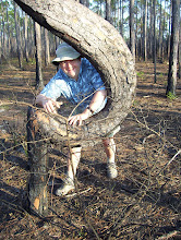
Finally, we made our way toward the Etowah River. By the river bank, we paused to view a large canoe that has been taking shape over the past couple years, a large tree trunk being hollowed out by fire. Someday, Ken hopes, the boat will take its maiden voyage down the Etowah....

Before returning to our cars and the opportunity for a quick lunch, we paused to gaze upstream, at a fishing weir that remains from the time Etowah was inhabited many hundreds of years ago, though it probably traps more canoes than fish nowadays. Looking at the weir now, I am reminded of a flock of geese, migrating south in the springtime. Or maybe that is just an effect of staying up well past midnight, working on this blog....


3 comments:
Clifford,
What is so nice about that particular fish weir is that you can view it from the relatively high bank which makes it easy to pick out. There are numerous fish weirs not only on the Etowah but also the Chattahoochee, Flint, and other GA rivers.
Your blog is a wonderful resource. Thanks for introducing me to it.
- Ben
I am writing a paper/article on how historic homes and societies can use new and alternate technologies in their work and am interested in getting more information on ground penetrating radars. Could you please point me in the right direction?
Thanks,
Denise
Denise:
I saw your note here on the blog. I am working with Clifford on some of his field trips/outings and am also the program director for The Legacy Center Museum. We have quite a number of associates who use Ground Penetrating Radar for a wide range of archaeological, historical, and geological applications.
If you will tell me a bit more about how you envision using GPR in your work or in the work of the people about which you are writing, I can put you in touch with the right person or people to help out.
I'll be waiting to hear back.
Ben Simms, Director
Outdoor Wisdom Leadership School
The "OWLS" Program
770-845-6900
Post a Comment